Friday, 1 December 2017

A cold night on Cold Pike & A meeting of 2 outdoor bloggers.

The Langdale Valley in the Lake District is an area I've walked several times. It is also very popular, but by carefull route selection it is still possible to miss the crowds- especially so in winter which is one of the many reasons It's my favourite backpacking season. The weather was looking good- cold with heavy snow showers- in my opinion the Lake District Fells are at their most spectacular in winter- snow covered peaks combined with cold air often brings very clear views, on a good day it's like viewing the fells through High Defination glasses!

I initially planned a circuit from lower Eskdale , a few messages between myself and Peter Dixon (@munro277 on Twitter) were exchanged during the week,  Peter had work on the Friday so we agreed he would meet me on Saturday for a walk and overnight camp and then walk sunday taking in a few fells on the way back to our cars.

A few days before the planned trip Peter messaged me to advise my route choice could be very wet going Due to the near constant rain over the previous days. A change of route was required and after a telephone call on Wednesday evening a rough route was planned in the Langdale Fells.

I intended to be away early Friday Morning to get there for sunrise. All was going to plan until I loaded my pack in the car. shutting the hatch I heard a cracking sound, on investigation I had snapped one of the clips on a compression strap, I needed to use it so I spent the next 3/4 hr. searching my bits boxes for a replacement. With a replacement found I was soon on my way again.

Around 3 hours later I pulled into Chapel Stile and got my kit sorted, then I headed off in the direction of Lingmoor Fell. The forecast had predicted strong winds but there was hardly a breath of it in the valley, and it was a pleasant warm walk through the woods, passing a quarry before emerging on the open fellside.


Welcoming committee


On a previous visit to this area I took the wrong path and passed some old quarry workings before ascending over pathless terrain to the intake wall. This time I took the same path to see if it was as I remembered - it was and I spent some time wandering around the various ruined buildings. It's an area seldom visited by other walkers and one I was lucky to find by mistake.Soon after I reached the stone wall and its a very straight forward walk following it to Lingmoor summit.


View NW along Lingmoor Fell.


The views along this modest fell are spectacular, the Coniston Fells on one side , Langdale Pikes on the other, With the upper langdale Fells straight a head.


Crinkle Crags from Lingmoor.


View ahead to the Langdale pikes from Lingmoor Fell.


Side pike and the Langdale Pikes from Lingmoor.

I descended towards Side Pike and from there to the valley road which I followed NW for a short while before heading up the grassy slopes towards Pike o Blisco. Part way up I spotted an idyllic looking spot by a stream with a superb view towards the Langdale Pikes. I decided to stop for lunch here - another aspect I like when backpacking, having everything needed for an extended time in the fells contained in my rucksack- free to wander, eat , sleep wherever I want it gives me a great sense of freedom.


The smile says it all.. Taking a break on ascent to Pike o Blisco.


Afternoon light on Side Pike.


Continuing up I was soon at the summit. Light snow showers came and went casting some lovely light on the surrounding Fell's. The wind was getting stronger - I recorded a wind speed of around 23 mph, with a wind chill of -4.7 c. After admiring the view and taking a few pics my attention turned to finding a pitch for the night. Originally I planned to camp on Little Stand - a spot I have camped at a few times, good pitch sites are limited there however and none would offer shelter from the strong North- North Westerly winds/heavy snow showers that were forecast over night. After surveying the area ahead I decided to head for Cold Pike. Dropping down towards Red Tarn I passed a photographer out capturing the evening light, and after a short chat I left him and continued on my way.

After passing Red Tarn I took the main path which leads to Crinkle Crags', before collecting water then heading over pathless slopes towards the summit of Cold Pike. Time was getting on now and the sun was getting lower in the sky, I took 1 last  photo of  late light on the Langdale Pikes  before hurrying to the summit to find a pitch for the night.
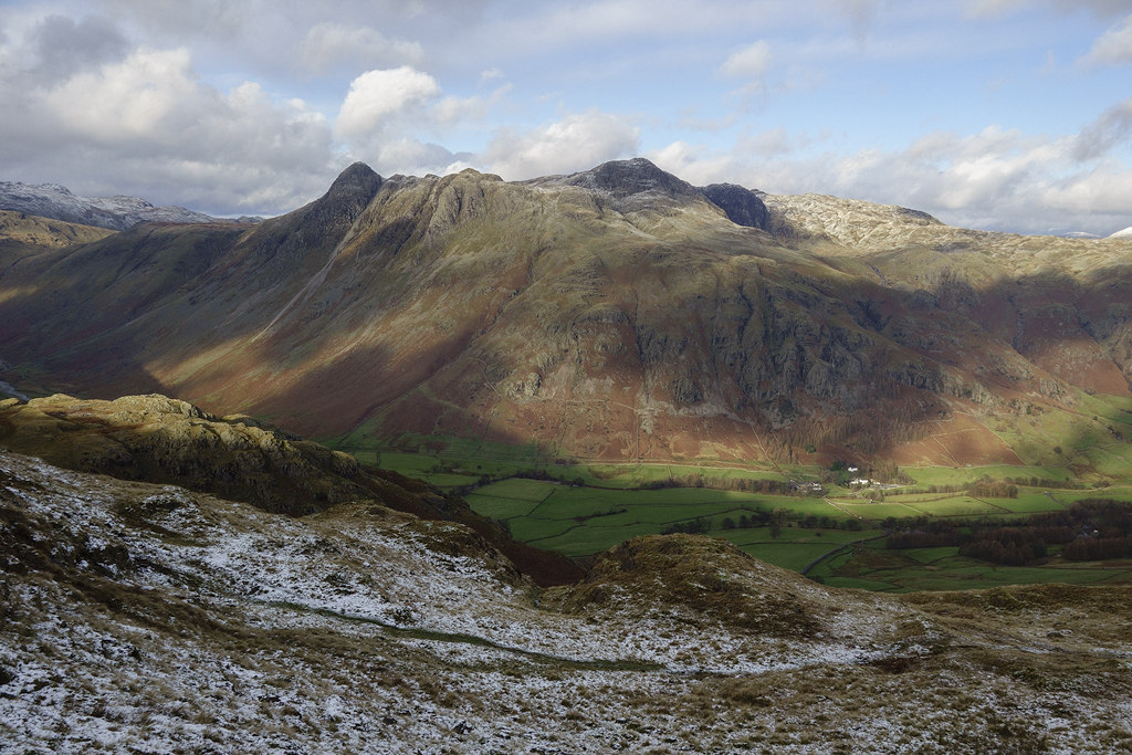


Langdale Pikes from flanks of Pike o Blisco.


Light near Pike o Blisco summit


Late afternoon light on the Langdale Pikes.


Nearing the summit I could see the signs of the weather closing in, the skies above the crinkles looking grey and menacing, seconds later I was engulfed in blizzard conditions with a strong biting wind - time to get the tent up! After scouring the area I found a spot on a shelf just off the summit, soon the Hilleberg Soulo was pitched and I was inside sheltered from the elements. I changed into my dry sleeping clothes before putting on my down jkt/pants, then I blew up the mat and got in the inner tent before sliding into my down bag and getting my cook gear out for a brew.

Outside I could hear the wind raging, blowing heavy snow/hail against the flysheet. I was warm, secure and content. I lay back for a while listening to the sound of the weather outside.

Shortly after, I followed my usual routine- 2 cuppa soups before opening the whisky and relaxing for an hour or two- I usually have dinner shortly after, but in winter I often eat it shortly before going to sleep- I find I sleep better/warmer that way.

Due to weather conditions at the time of pitching I couldn't get any camp pics, but I managed to get 1 night shot before turning in for the night.


stars and another incoming blizzard form camp on Cold Pike.


I awoke the next morning about 3/4 of an hour before sunrise. Un-zipping the outer tent door a little I surveyed the scene, there were signs of some good pre dawn light so I made a brew before getting out for a few pics. A good covering of snow had fell in the night, and I was excited to see what sunrise would bring.


early morning light from Cold Pike.


Hilleberg Soulo on Cold Pike.


I had planned to meet peter today, I'd messaged him the night before to let him know where I was camped, he sent me a message back saying he would aim to get to me around 9 and asked if I wanted anything bringing ( I did consider asking for some cans of real ale but didn't want to push my luck ) I messaged back to say a bacon & egg sandwich with brown sauce would go down well - the reply came back- Don't take the P*** Daron !! :-)).

I packed most of the kit away- expect the tent and stove, then went to the summit to see  if I could spot Peter- we got to there at the same time! Back at the tent I made him a brew before striking camp and moving on.

We continued on towards Crinkle crags, frequent snow showers combined with a strong wind blew a lot of spindrift around, Peter got some great footage of it he posted it on his blog. http://wanderingsupnorths.blogspot.co.uk/

Nearing 3 tarns Peter suggested we find a sheltered spot for lunch - finding 1 amongst the boulders strewn over the area. He gave me the Bacon and Chicken sandwich he'd got for me then, as I was about to tuck in, he produced a sachet of brown sauce - a true friend indeed :-).

cloud and incoming blizzard from near Crinkle Crags.


Peter capturing a winter scene.


Bow Fell and Esk pike from near Three Tarns.


Scafells from near Three Tarns.


The Langdale Valley from Crinkle Crags.


After lunch we continued to Bow fell to zero views, before heading to Ore Gap then Descending towards Angle Tarn. Approaching the Tarn we discussed pitch spots, eventually we decided to find a spot on Rossett Pike and set off towards the summit. Once there were scoured potential spots before finding a lovely spot high above the langdale valley. Shelters pitched, we set of to source water- the first site, despite the water line  showing a steep fall on the map  was dry , even though there had been very heavy rain on the previous days- it obviously drains quick ! we tried another site on the opposite side of the ridge, this time finding good running water.

Back at our shelters we retired to rest, eat and drink we hoped we might get some clear skies for some good night shots - It was not to be, constant strong winds with gusts to 40 - 50mph combined with snow/hail put paid to that !


Camp on Rossett Pike.


It was a very windy but comfortable night , I had slept well in the soulo - It had passed another test with flying colours. Peters Trailstar had also shed the weather with ease - no surprise here... I have owned 1 for the last 4 yrs, and know it well.

There were signs of good pre dawn colour showing through , so I made my morning coffee before getting ready to capture it... it wasn't to be, the  showers continued for a while, but stopped to allow some good shots of early morning light.


Pre Dawn light from Rossett Pike.


Peter and his Yellow Mountain Laurlel Designs Trailstar.


Langdale light.


Hilleberg Soulo on Rossett Pike.


Camp on Rossett Pike.


Light in the Langdale valley.


After breakfast we discussed the days route. I had intended to go onto the langdale's then down Blea Rigg back to chapel stile. In the end we decided to descend to langdale over a few 'bumps' before taking the Stake Pass Path/ Cumbria Way back to langdale. Before descending Peter took a wind speed / temperature reading - 54mph gusts, with a wind chill of around -14 deg. c !

Soon we reached the valley and a while later we arrived at Peters car. He then gave me a lift back to my car which I'd left at chapel stile. Another splendid winter backpack done with top company....cheers Peter!

As usual.. till next time
Happy Wildcamping
Daron :-))

Map of route :


Sunday, 19 November 2017

Winter on Aran Fawddwy - an overnight wander.

Located in South East Snowdonia the Aran group of mountains to the south of Llyn Tegid (Bala ) are very underrated, Despite it containing many fine summits including the highest in the range - Aran Fawddwy. It is often very quiet with the vast majority of folk ignoring them for the lure of  'honey pot' summits further north - their loss is my gain  and I seldom see many people here on my trips.

I planned this walk as a day walk, that was until my Wife planned a night out so I jumped at the chance of a night out in the hills . I had the choice to go with her - a night out at the dogs , or a night on a mountain summit. It was, for me an easy decision.

Pulling into the car park at Llanuwchllyn I got out of the van to get Myself ready, the roaring sound of the nearby Afon Dyfrdwy indicated the extent of the previous days rain , it was quite mild with drizzle so I donned a windshirt over my base layer , grabbed my pack and took the familiar lane south on the Western side of river .

Further on a signed path branches of SW crossing a very boggy field to a Ladder stile where the path contours around the base of  Garth Fach.

The weather today rendered the landscapes a very muted grey - not the best for photography there was however some nice mist/ cloud on the higher tops to add a bit of interest, so I took a few pics as a record of the day.


Looking South along the Aran's ridge

The path continues past some rocky/craggy summits each one getting higher, affording terrific views on a good day to the valley floor. I've detoured for the views many times, but today there was no point - mist obscuring the views so I stuck to the path.

Looking North along the Arans ridge


Continuing on and getting higher all the time I soon reached Aran Benllyn and Aran Fawddwy came into view. Wandering over to one of the small pools enclosed amongst the crags I found a sheltered spot for a leisurely brew/lunchbreak,I spent around 1/2 hr here in no rush to move on, today was not about miles but more taking time to expore the various nooks and crannies along the ridge.After lunch I continued on to the cairn at the southern end perched on the brink of a precipitous drop - great views from here down to Creiglyn Dyfi a delightful spot where I have camped on a few occasions.

Aran Fawddwy with Drysgol beyond.


This trip I had planned to camp on Aran Fawddwy- a summit I've wanted to camp on for a while. Snow was forecast from the afternoon onwards, I was looking forward to the return of the white stuff - winter wildcamping is the best season (to me) to be out in the hills.

Continuing on I commenced the climb to Aran Fawddwy detouring from the path to explore out of the way potential wildcamp spots , I found quite a few places perfect for bivying, hidden behind rocky outcrops but none big enough to get my tent in.


Creglyn Dyfi from ascent of Aran Fawddwy


I had marked a possible spot on the map beforehand - the widley spaced contour lines showing the possibility of finding a level pitch with a water source nearby so I continued on southwards .
Not long after leaving the summit area I spotted a likely looking spot just of the path , with rocky outcrops for shelter/privacy so I wandered over to investigate - it turned out to be a perfect site - level grass at a little over 2800ft with superb views southwards towards Gwaun y Llwyni. I marked its position then set off to locate water a little further down.

The heavy rainfall over the previous days meant there was running water above the stream line shown on the map so I collected around 4 ltrs of very clear water ( 4 ltrs is the minimum I need for max and myself ) I then commenced to walk back uphill to my spot - it seemed to take forever, no doubt partly due to the 4kg of extra weight I added to an already heavy pack - good fitness training though.

Back at the spot I had found earlier I dropped my pack and set about pitching my Hilleberg Soulo. Soon my 'hotel 'for the night was up and I moved in .


Pittch on Aran Fawddwy.


Pitch on Aran Fawddwy


Pitch ov Aran Fawddwy.


Once inside I put my newly acquired Msr Windpro 2 stove on for a brew, I got this specifically for winter camping to give me better snow melting capability for when the need arises, I have done this with my meth's stoves but it is a very slow process. The much quicker boil times are an advantage in winter as well .. esp. when you're cold and want to quickly make a hot drink to warm up.
I spent that evening lying in my bag , outer tent door open taking in the view whist cooking/eating dinner , a few hot drinks before relaxing with my usual tipple on wildcamps - single malt whisky.


View from tent door  towards Gwaun y Llwyni with the Dyfi Hills beyond


I must have drifted off to sleep, the wind picked up and it started snowing a few snowflake's falling on my face awakening me. I closed the outer door before making an hot chocolate then lying back listening to the wind- snow on the flysheet , I love the feeling of being snug in a down bag , listening to the sound of wind /rain /snow with only a very thin fabric to protect me   its a sensation I never tire of !
I awoke once more during the night the winds had got stronger the Soulo was rock solid it felt very secure and soon I drifted back to sleep.

Morning came and I unzipped the outer door to survey the scene before me -there was a light snow covering. reaching for my skywatch which I'd left out over night I wiped the frost off and took a temperature reading -1 c , I couldn't take a wind chill reading as the propeller had iced up and froze over night, the thick layer of frost on the stiff guylines told me it was probably several degrees below freezing though.As I lay there drinking my morning coffee it started snowing quite heavily accompanied by strong winds, just a shower I thought..

Around 45 mins later ( After breakfast followed by more coffee ) the snow shower passed, I peered out of the tent door - around 2-3 cm had fallen, I then started to slowly pack everything away. whilst doing so it started snowing again, so once I had packed everything away under cover, I made 1 last coffee before getting myself and Max ready to strike camp. I put max's winter walking coat on, then got out of the tent to attempt to pack it away quickly - not easy when its blowing a gale combined with snow . Max sat there with a disapproving look, his face covered in snow. The tent was quickly stuffed into its sack and we headed off.

Usually I'm not a fan of 'out and back walks ' as I said at the beginning this was supposed to be a day walk but I turned it into a 2 day slack pack - I'm glad I did  as it gave me time to explore and get different perspective's without being constrained by the time frame of a longer walk.

Slowly I made my way back to Llanuwchllyn over snow covered summits views back to Bala looking much different to the day before. It was a very different kind of trip from the usual but  I enjoyed immensely- it was more of an 'immersive' trip, a chance to stop and stare, take in the mountain with all its changing character through different weather conditions. Soon I was back at my starting point  and another journey started... this time though I was heading home.

I'll leave you with some pic's from my journey back to Llanuwchllyn.

Thanks for taking the time to read.

Till next time , happy Wildcamping

Daron :-)


View East from descent of Aran Fawddwy.


Aran Benllyn from Aran Fawdddwy.


Moel Llyfnant & Arenig Fawr from Arans ridge.


Approaching Llyn Pen Aran.


Llyn Pen Aran & Aran Benllyn.


Llyn Lliwbran.


Sunday, 22 October 2017

3 days in the Black Mountains.

The Black Mountain's located on the eastern fringes of the Brecon Beacons (Not to be confused with Black Mountain on the western side of the Brecon Beacon's ) Is an area I've never visited, despite it only being around a 2hr drive from where I live .Over the years  much of my walking and back packing has been concentrated around Snowdonia , Lake District , The Berwyns & The Peak District .

I've covered many, many miles in these area's, to the extent that it was becoming very familiar territory .. I was in need of some new ground to explore . The Black Mountain's fitted the bill nicely .


Day 1 12.9 miles ascent 2898ft. descent 2035ft.


On line research led me to a nice start /finish at a car park at the foot of Black Hill. I had 3 day's to play with so I came up with a rough route which I could change depending on weather conditions .

The forecast for the weekend was mainly dry but with strong winds ahead of storm Ophelia arriving Sunday into Monday .A good choice to test my newly acquired Hilleberg Soulo which I bought with snowy winter camps in mind .

Pulling into the empty car park at around 8pm I surveyed the conditions - light drizzle with a strong wind  the higher tops still in cloud. It was very mild for the time of year so I decided on a windshirt over my very light base layer  before shouldering my pack and setting off on the steep climb to Black Hill.


looking back towards the car park from Black Hill


view south on ascent of Black Hill


Soon I reached the summit , the higher tops were beginning to clear with signs of brightness appearing. There were some nice views towards Hay Bluff - which I intended visiting on my way back in 3 day's time .

Black Hill summit


looking towards Hay Bluff form Black Hill


Next my attention turned to The Black Mountains ridge and I  branched off to pick up the Offa's Dyke path running along it's spine. This turned out to be a very nice high level walk , and I followed it all the way down to a cairn at spot height 552 mtrs before heading west to cross the Vale of Ewyas , before ascending to Bal Bach via Cwm Bwchel.

Looking back to black Hill


looking south along the Offa's Dyke path along the Black Mountain ridge


light on Black Hill from the Offa's Dyke path


View across the Vale of Ewyas to Bal Mawr


light in the Vale of Ewyas


Llanthony Priory ruins.


It was quite a warm climb to Bal Bach in warm Autumnul sunshine and the cooling breeze on reaching the top was most welcome . The bracken looked splended in it's full autumn colours - rich orange / brown , it would be gone in a few weeks as the seasons shift from autumn to winter .


Autumn colours from Cwm Bwchel.


Ahead was Bal Mawr and I set of towards it's summit arriving soon after . I surveyed the route ahead the set off looking for a place to camp along the way . The ridge is mostly covered in heather, so I checked out a few possibilities - a few sheep nibbled patches  in amongst the bracken on the steep sides - but none turned out to be flat enough . I eventually settled on a spot just south of Chwarel y Fan - nice and flat on a patch of shortish heather . It was very exposed though- the strong winds ( later measured at a constant 45 mph) would be a good 1st test of the Hilleberg Soulo ! it has a good reputation for being a good solid shelter , so I set it up and put my faith in the guylines preventing it- and me from being blown of the hillside .

The 1st pitch went well , but the heather meant I couldn't get the bottom pegs around the base in sufficiently to get the flysheet taught . Despite a bit of flappy fabric however, it felt solid and secure as the winds did their best to detach us from the mountain .


Bal Mawr.


pitch near Bwlch Bach.


Morning came  and I still had a flysheet above my head , I had slept very well - the heather providing a nice soft and comfortable bed for the night . Lighting my meth stove for a brew I snuggled back down for a few minutes whilst I waited for the water to boil.

Whilst enjoying breakfast I downloaded the latest weather forecast which wasn't looking good - particulary the period sunday  evening to Monday morning ... after a dull start it would brighten up before storm force winds with gusts to 70 - 80mph arrived , the exact timing of this was uncertain . I thought about heading back in case it came early, but in the end I decided to descend to see if I could find a sheltered spot for the night , at the same time exploring a bit more of the surrounding area.

Once breakfast was finished I set about packing ready to strike camp . whilst taking down the tent  a couple of back packers came along the ridge " not windy enough for you up here then ? " they jokingly said - they had camped down in the valley  but me being a stubborn sod I always try to camp as high as possible... for the better views.

Once everything was packed and the 'idiot' check was done I set off towards Chwarel y Fan under bright blue skies.


Day 2  12 miles ascent 1521ft. descent 1655ft.


 Grwyne Fawr Resevoir.


Chwarel y Fan.


Shortly after the summit of Chwarel Y Fan I branched off on a descending path towards Grwyne Fawr Resevoir.
Grwyne Fawr Dam.


A little further up I descended to check out the bothy , a lovely spot next to the inlet stream at the northern edge of Grwyne Fawr Resevoir . It is a fairly compact bothy , and initially I could see any where to sleep until I spied an iron ladder leading to a small sleeping platform just big enough for 2 .


I intended returning later if the weather turned grim , but would need a plan 'b ' in case it was occupied. I continued on keeping an eye out for a good sheltered spot along the way.


Grwyne Fawr Bothy.


Inside Grwyne Fawr Bothy.


A few miles on I came across a lovely sheltered spot on some raised ground beside the stream .
It was only 12 pm though - far too early for a camp so I added it as a poi in viewranger in case I needed to return later .

Still having a good few hours of walking time ahead, I quickly planned a route and headed for Waun Fach  taking a slanting line over mostly pathless terrain towards Pen y Manllwyn .


 Unfortunately upon arrival I was greeted with zero views , the thick clag making it feel a very bleak place - not a place to linger today.

Heading back to Pen y Manllwyn I continued north on the path passing Y Crib ( also known as the dragons back ) before continuing North East to the summit Cairn at Rhos Dirion, passing a lovely herd of wild ponies along the way.


Wild Welsh Pony .


Rhos Dirion summit .


From Ros Dirion I headed south east towards Twyn Talycefn before descending towards spot height 607 m from where I descended back towards Grwyne Fawr Resevoir , this time taking a walk along the dam wall .


Heading towards Twyn Talycefn


view from Grwyne Fawr Dam


Autumn Colour.


By now it was getting late  so I decided to head for the spot I found earlier where I set up camp for the evening . This time the ground was better and I was able to get the base pegs in better - resulting in a much tighter pitch .


Pitch near the Grwyne Fawr.


After fetching water from the nearby stream I settled down and spent a leisurely evening cooking dinner , a few brews , before relaxing with the rest of the very nice single malt I had with me .

Around dawn there were some hefty showers and I again lit the meths stove before lying back listing to the patter of rain drops on the flysheet.

Another leisurely breakfast was consumed then I packed every thing  away inside the tent ,  before getting out and quickly dropping the tent before heading back to Rhos Dirion.


Day 3 8.7.miles ascent 1406ft. descent 2140ft.


From there I continued to Lord Hereford's Knob ( Twmpa ) then descended to the lane before climbing back up to Hay Bluff.


looking back towards Twmpa.


Hay Bluff summit .


From there I headed back to Black Hill taking 1 last time to look back at the views before heading back to the car park . The winds were getting very strong - knocking me of my feet on a few occasions !

A wind speed / temp reading was taken on my skywatch - around 57 mph constant , 75 mph gusts and a very mild 17.5 c . storm Ophelia was here ... time to get back down.

It had been a very enjoyable 3 days in some new ground , and I look forward to returning to explore further.


Looking north from Black Hill.


Till next time...
Happy Wildcamping
Daron :-)